Home] -
Live Cams
] -
Current WX
] -
Forecasts
] -
Radar
] -
(
Satellite
) -
WX Maps
] -
Long-Range
] -
Precip
] -
Climate
] -
Links
] -
Books
] -
Radar Images
KRON Doppler
.
Intellicast Nexrad
.
TWC Doppler
.
Satellite Images
NRL Infra-Red
.
NRL Water Vapor
.
Local Forecasts
WeatherPages 7-Day
.
KRON Weather
.
Traffic Reports
PIX Page Traffic
.
ETAK
.
WeatherPages
Live Cams
.
Fcst. Models
.
Bay Area - NRL
(Visible)
Northern CA - NRL
(Visible)
CA - NOAA AVHRR
(Infra-Red)
KRON
(Infra-Red)
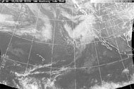
Infra-Red
*
NRL
- [
Animation
]
UC Davis
- [Anim:
B&W
,
Color
]
SFSU
NOAA
- [
Animation
]
Yahoo/WNI
Earthwatch 3D
Enhanced IR...
Purdue
,
NWS
,
UCD
IR Composite...
Surface
,
500mb
,
300mb
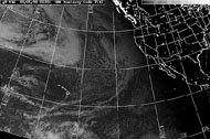
Visible
*
NRL
- [
Animation
]
U.C. Davis
- [
Animation
]
NOAA
- [
Animation
]
SFSU
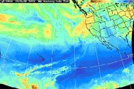
Water Vapor
*
NRL
- [
Animation
]
U.C. Davis
NOAA
- [
Animation
]
Purdue
Infra-Red
Visible
Water Vapor
WeatherPages for:
Home
|
Features
|
News
|
Search
|
Chat
|
Links
|
History
|
Feedback
Copyright © 1998
Matt Haugland
. All rights reserved.
Local
...
Understanding different types of satellite images
Click on a satellite picture below to learn more about it...
Search